Documents including Autographs
Lot 4016 Session 12 (11.30am Thursday) Documents including Autographs
Estimate $200
Bid at live.noble.com.au
SOLD $220
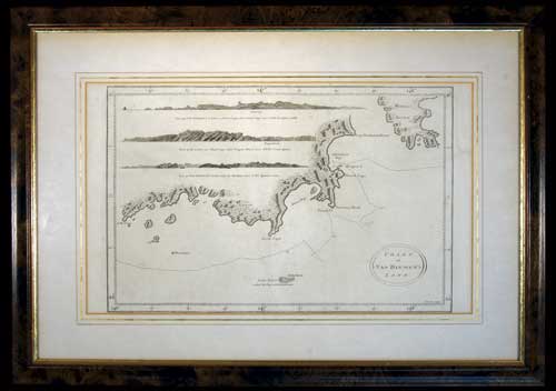
VAN DIEMEN'S LAND CHART, in b&w (approx 37.5x22.5cm), lithograph by T. Bowen, sculp., published in London c1793, features three coastal profiles namely, View of Van Diemen's Land over Fluted Cape, when South Cape bears NNE 1/2 E distant 7 miles; View of the Land over Fluted Cape when Penguin Island bears NWbW 1 1/2 mile distant; View of Van Diemen's Land when the Mewstone bears N 1/2 E distant 5 miles; this is a nautical chart of the coast of Tasmania from S.W. Cape to Maria's Isles showing the track of the Resolution on Captain Cook's third voyage in 1777 with relief shown pictorially and depth shown by bathymetric soundings, matted and framed under glass (approx 53x37cm). A few faint foxing spots on map and an edge tear on the border but not affecting the map, otherwise fine and scarce.
Estimate / sale price does not include buyer's premium (currently 22% including GST) which is added to hammer price. All bids are executed on the understanding that the Terms & Conditions of sale have been read and accepted. For information on grading and estimates please refer to the Buying at Auction advice.
Quick find
View a lot by number and sale.
Adjacent lots
Lot 4014
CAPTAIN COOK'S THIRD VOYAGE LITHOGRAPH, The Reception of Captain Cook in Hapaee, (Tonga) by J. ...
Estimate $60
Lot 4015
WORLD MAP, 1776, A Chart shewing (sic) The Track of the Centurion round the World, ...
Estimate $60
Lot 4016 This lot
VAN DIEMEN'S LAND CHART, in b&w (approx 37.5x22.5cm), lithograph by T. Bowen, sculp., published in ...
Estimate $200
Lot 4017
NEW SOUTH WALES MAP, (approx 34x26cm), published Jan 4 1828 by Samuel Arrowsmith, No. 10 ...
Estimate $350
Lot 4018
CARTE DES ISLES BRITANNIQUES, map of the British Isles with the kingdoms of England, Scotland ...
Estimate $30