Documents
Lot 3980 Session 13 (2.30pm Thursday 26 March) Documents
Estimate $500
Bid at live.noble.com.au
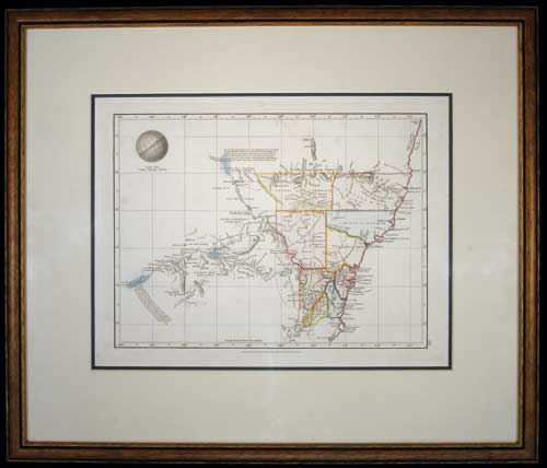
NEW SOUTH WALES MAP, (approx 34x26cm), published Jan 4 1828 by Samuel Arrowsmith, No. 10 Soho Square, London, features relief shown by hachures and spot heights, includes explorers' routes, also description of topography and boundaries of nine Counties in colour, matted and framed under glass (51x43cm). A few areas of light foxing, otherwise very fine and a scarce early Colonial map.
Estimate / sale price does not include buyer's premium (currently 22% including GST) which is added to hammer price. All bids are executed on the understanding that the Terms & Conditions of sale have been read and accepted. For information on grading and estimates please refer to the Buying at Auction advice.
Quick find
View a lot by number and sale.
Adjacent lots
Lot 3978
WORLD MAP, La Mappe-monde ou le Globe Terrestre en deux Hemispheren Oriental & Occidental 1806 ...
Estimate $200
Lot 3979
WORLD MAPS, includes Australia pre 1900 with Hobart Town shown, by J. Archer, published by ...
Estimate $500
Lot 3980 This lot
NEW SOUTH WALES MAP, (approx 34x26cm), published Jan 4 1828 by Samuel Arrowsmith, No. 10 ...
Estimate $500
Lot 3981
VAN-DIEMANS LAND MAP, (approx 35x42cm) in colour, drawn and engraved by J. Dower, Pentonville, London ...
Estimate $100
Lot 3982
NEW ZEALAND MAP, Carte de la Nouvelle-Zelande pour servir au Voyage pittoresque autour du Monde ...
Estimate $400