Documents including Autographs
Lot 4017 Session 12 (11.30am Thursday) Documents including Autographs
Estimate $350
Bid at live.noble.com.au
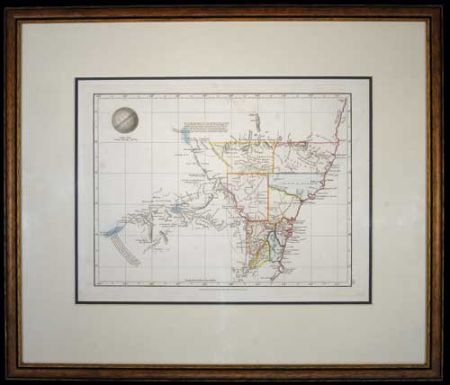
NEW SOUTH WALES MAP, (approx 34x26cm), published Jan 4 1828 by Samuel Arrowsmith, No. 10 Soho Square, London, features relief shown by hachures and spot heights, includes explorers' routes, also description of topography and boundaries of nine Counties in colour, matted and framed under glass (51x43cm). A few areas of light foxing, otherwise very fine and a scarce early Colonial map.
Estimate / sale price does not include buyer's premium (currently 22% including GST) which is added to hammer price. All bids are executed on the understanding that the Terms & Conditions of sale have been read and accepted. For information on grading and estimates please refer to the Buying at Auction advice.
Quick find
View a lot by number and sale.
Adjacent lots
Lot 4015
WORLD MAP, 1776, A Chart shewing (sic) The Track of the Centurion round the World, ...
Estimate $60
Lot 4016
VAN DIEMEN'S LAND CHART, in b&w (approx 37.5x22.5cm), lithograph by T. Bowen, sculp., published in ...
Estimate $200
Lot 4017 This lot
NEW SOUTH WALES MAP, (approx 34x26cm), published Jan 4 1828 by Samuel Arrowsmith, No. 10 ...
Estimate $350
Lot 4018
CARTE DES ISLES BRITANNIQUES, map of the British Isles with the kingdoms of England, Scotland ...
Estimate $30
Lot 4019
NEW ZEALAND MAP, Carte de la Nouvelle-Zelande pour servir au Voyage pittoresque autour du Monde ...
Estimate $280