Documents
Lot 1977 SESSION 8 (2.30PM TUESDAY 31ST AUGUST) Documents
Estimate $500
Bid at live.noble.com.au
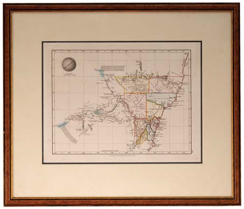
NEW SOUTH WALES MAP, (approx 34x26cm), published Jan 4 1828 by Samuel Arrowsmith, No. 10 Soho Square, London, features relief shown by hachures and spot heights, includes explorers' routes, also description of topography and boundaries of nine Counties in colour, matted and framed under glass (51x43cm). A few areas of light foxing, otherwise very fine and a scarce early Colonial map.
Estimate / sale price does not include buyer's premium (currently 22% including GST) which is added to hammer price. All bids are executed on the understanding that the Terms & Conditions of sale have been read and accepted. For information on grading and estimates please refer to the Buying at Auction advice.
Quick find
View a lot by number and sale.
Adjacent lots
Lot 1975
CAPTAIN COOK'S THIRD VOYAGE LITHOGRAPH, The Reception of Captain Cook in Hapaee, (Tonga) by J. ...
Estimate $500
Lot 1976
CAPTAIN COOK'S THIRD VOYAGE LITHOGRAPH, An Offering before Capt Cook, in the Sandwich Islands, by ...
Estimate $500
Lot 1977 This lot
NEW SOUTH WALES MAP, (approx 34x26cm), published Jan 4 1828 by Samuel Arrowsmith, No. 10 ...
Estimate $500
Lot 1978
NEW ZEALAND MAP, Carte de la Nouvelle-Zelande pour servir au Voyage pictoresque autour du Monde ...
Estimate $300
Lot 1979
AUSTRALIA MAP, in colour (approx 28.5x24cm), c1880, showing Alexandra Land and North Australia (these now ...
Estimate $500