Documents
Lot 1978 SESSION 8 (2.30PM TUESDAY 31ST AUGUST) Documents
Estimate $300
Bid at live.noble.com.au
SOLD $260
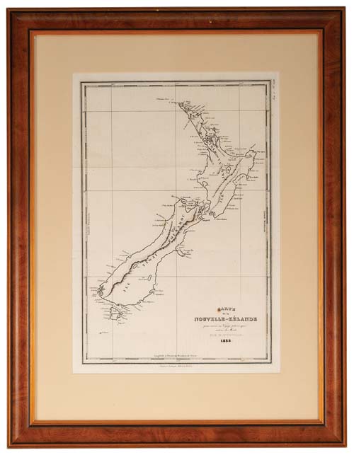
NEW ZEALAND MAP, Carte de la Nouvelle-Zelande pour servir au Voyage pictoresque autour du Monde par M. d'Urville 1835 (map of New Zealand for use in the scenic trip around the world by M. d'Urville in 1835), drawn and engraved by Ambroise Tardieu, in b&w (approx 23.5x34cm), shows north and south islands with Maori names of Ile Ika - Na - Mawi and Ile Tawai - Pounamou, matted and framed under glass (approx 39x51.5cm). A few spots of foxing and folds, otherwise very fine and scarce.
Estimate / sale price does not include buyer's premium (currently 22% including GST) which is added to hammer price. All bids are executed on the understanding that the Terms & Conditions of sale have been read and accepted. For information on grading and estimates please refer to the Buying at Auction advice.
Quick find
View a lot by number and sale.
Adjacent lots
Lot 1976
CAPTAIN COOK'S THIRD VOYAGE LITHOGRAPH, An Offering before Capt Cook, in the Sandwich Islands, by ...
Estimate $500
Lot 1977
NEW SOUTH WALES MAP, (approx 34x26cm), published Jan 4 1828 by Samuel Arrowsmith, No. 10 ...
Estimate $500
Lot 1978 This lot
NEW ZEALAND MAP, Carte de la Nouvelle-Zelande pour servir au Voyage pictoresque autour du Monde ...
Estimate $300
Lot 1979
AUSTRALIA MAP, in colour (approx 28.5x24cm), c1880, showing Alexandra Land and North Australia (these now ...
Estimate $500
Lot 1980
TONGA, Plan of Tongatapu scale map (approx size 70x50cm), a vintage map on dark pink ...
Estimate $50